Capacity strengthening for gender responsive and sustainable urban development: Integrated Deprivation Area Mapping System for Displacement Durable Solutions and socioeconomic reconstruction in Khartoum, Sudan (IDeAMapSudan)
Requesting Organization
Sudan Urban Development Think Tank (SUDTT).

Training providers
- Faculty of Geo-Information Science and Earth Observation of the University of Twente (ITC), Netherlands
- African population & health research centre (APHRC), Kenya
- Université Libre de Bruxelles (ULB), Belgium
Main Beneficiaries
- Ministry of Labour and Social Development
- Ministry of Infrastructure and Transport
Training Fund
This project is part of the Orange Knowledge Program (OKP) funded by the Dutch Ministry of Foreign Affairs and managed by Nuffic.
Purpose and Objective of the Training
In Nov 2019, SUDTT organized a workshop under the title: Climate Change Security, Conflict and Displacement with the participation of 30 representatives from national bodies, local and international NGOs, research and academia. The workshop identified a clear gap in spatial information about the physical location and structure of deprived areas in Khartoum while also linking it to the socio-economic and socio-cultural issues within these areas. The need was identified for capacity building within the ministries dealing with these issues and also within relevant civil society organisations and NGOs. The identified capacity gaps can be traced throughout all the links of the chain that constitutes a complete information system. These are:
- lack of spatial data creation and collection
- lack of data management and analysis
- lack of the ability to translate spatial data into relevant policy
The identified gaps guided the scope and purpose of this training program to develop a community-led geo-spatial database for mapping informal settlements that will support the decision making process for displacement socio-economic reconstruction.
This training aims to map and fill the gaps in the government of Sudan institutional and technical capacities, required to create a comprehensive database on displacement patterns and informal settlements in Khartoum, and support political governance in form of decision making processes for displacement durable, sustainable and resilient solutions.
SUDTT, together with the project partners will work collaboratively with local governments and civil society organisations, providing training on the use of digital maps produced from satellite imagery to map urban deprived areas /informal settlements, and link the geospatial data collected with community-based data and data from capacity and vulnerability assessments, creating an understanding of displacement challenges and opportunities associated with urban development and socio-economic reconstruction reforms in Sudan.
Integrated Deprivation Area Mapping System in Sudan (IDeAMapSudan) – CONCEPT
The training will focus on building the capacity to co-create and use spatial data on deprived areas (informal settlements). The training proposed will help to frame an ‘Integrated Deprivation Area Mapping System’, that is essential for developing a comprehensive roadmap for resilient and sustainable urban planning strategies for durable solutions to displacement in the Horn of Africa in general, and Sudan in particular.
Training Project Structure
The TMT will be structured into four main Training Packages (TP):
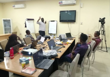
- TP 1) is basic spatial data analysis training of policy leaders, academia and representatives of NGOs and community-based organizations. This training will provide a deep gap analysis, political support and access to relevant stakeholders. The results will also allow to frame TP2 (training of trainers: ToT).
- TP 2) is the advanced technical training of 9 young trainers (ToT) to co-create and sustain IDeAMapSudan (gender ratio: 5 female and 4 male). Integrating the observations from TP1 into an advanced technical training of the ToT. This will help to co-create and sustain IDeAMapSudan.
- TP 3) is the training of different stakeholder groups (ranging from communities to policymakers) to use spatial data supported by IDeAMapSudan, and to use this system as a platform for urban management, participation, empowerment and livelihood generation. The main lessons learned will be disseminated in form of best practice guides and used to frame TP4. Focused on two main areas, community-based mapping training will take place in Jabal-Awliya (South Khartoum), and West Omdurman as pilot projects.
- TP4) is the training and knowledge exchange to other parts of Sudan and across neighbouring countries to support peacebuilding in the Horn of Africa (South Sudan and Somalia) for scaling up the system beyond the implementation in Khartoum.
Training Outcomes
The main outcomes of the training will be a small group of experts (ToT), a large group of diverse users of spatial information to support sustainable urban development of deprived areas and an operational spatial information system (IDeAMapSudan) that includes a mobile app to collect and access spatial information.

Professor Robert Brown
“At the heart of Tuti resident’s collective action is the Sudanese cultural tradition of Nafir and a spriti of solidarity an generosity towards others. What is also remarkable is the sense of Nafir present in the team itself.”

Mark Harvey
“By studying in depth and highlighting the dynamics and properties of the historically-embedded and community-owned Sudanese flood Early Warning System, the ‘Taya’ system of Tuti Island, SUDTT has managed to give prominence to the importance of traditional disaster risk reduction (DRR) mechanisms in community-based climate resilience efforts. Notably, this has been undertaken by SUDTT in a way that has galvanized the attention of the rapidly growing global community of climate adaptation, climate resilience, and climate DRR experts.”

Dr Mohamed Salah Eldin Mudawi
“With appropriate funding and support, this project could amplify the utilization of indigenous practices and experiences for the benefit of numerous other similar communities.”

Barbara Minguez Garcia
“I can’t express enough how proud I am of this team of professionals, and how much I admire their dedication and resolution, together with the commitment of the local community members in Tuti Island, who joined forces to face the very adverse situation and continue preserving and using their traditional knowledge to increase their own resilience.”

Faith Chivava
“A standout feature of the HEART project is its comprehensive engagement across all levels of stakeholders—from grassroots participants to policymakers at local, national, regional, and international tiers.”

الشهيد عباس فرح
ملتزم بالعصيان حتى تتحقق أهداف الثورة

الشهيد أستاذ أحمد الخير
يا كاتب التاريخ هيا حينا
وامدد يديك مصافحاً أيدينا
وامسح بدمع الأشقياء حكومةً
حكمت علينا بالبكاء سنينا
أحمل كتابي للحكومة قل لها
تتلو على أرواحنا ياسينا
وإذا عزمت فلا تكن متردداً
ولك السلام وما مضى يكفينا
الشهيد أستاذ أحمد الخير

الشهيد محمد الفاتح النمير
انا لست رعديداً يكبل خطوه ثقل الحديد

الشهيد عبدالسلام كشة
نخاف على ثورتنا من النخب

الشهيد محمد هاشم مطر
حرام علينا يروح دم الشهيد هدر

